|

West Of Southwell
|
|
|
© OpenStreetMap contributors - see http://www.openstreetmap.org/copyright
|
|
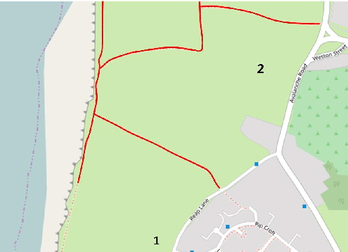
This area is mostly large rough fields between Reap Lane, Avalanche Road and the cliff edge.
An archaeological dig in the area off Reap Lane [1] was visited on July 31st 2017 and the pictures shown below were taken.
The rougher pasture land [2] was a deep quarry, Grangecroft, until the 1960s when it was filled in and cultivated. Now there is hardly any clue that this was once a large hole apart from a few boulders breaking the surface near the junction of Reap Lane and Avalanche Road.
Please click here for a detailed map. The arrow points to the centre of this area of interest. Click the BACK button on your browser to return to this page.
Please click here to visit the satellite image of this area on Google Maps. Click the BACK button on your browser to return to this page.
For a Google Street View link to this area please click here.
|
Please use this table to navigate around this page
|
|
ARCHAEOLOGICAL DIG [1]
|

|
|
R****TS!
|

|
|
ANOTHER OF MY HOBBIES
|

|
|
ARCHAEOLOGICAL DIG REAP LANE [1]
In 2013 an archaeological dig was started at a site to the west of Reap Lane. On a visit to the site on 31st August 2017 the following pictures were taken and I had a very interesting chat to the “diggers” who were hard at work.
An overview of the site taken by Stuart Morris using a drone can be viewed here.
A report on findings up until the end of the 2016 can be read here.
This plan was drawn by me on my visit to the site. It is not to scale and it does not in any way represent the actual layout of the site other than to identify the pictures below. The two dotted lines are approximately the lines of stones possibly from the Mesolithic age as discovered so far.
Site ‘A’ showing a deep cavity in the near corner. This is shown in close up below.
Site ‘B’ which is to the west of the main dig cluster. It has a fractured layer of rock.
In the foreground is site ‘C’ which is apparently beyond the end of the two lines of stones.
Beyond is site ‘D’ on the plan above.
In the foreground is Site ‘E’ with Site ‘F’ beyond with the yellow bucket inside.
In the foreground is Site ‘G’ with Site ‘H’ beyond.
Site ‘H’ showing the spur trench with a stone probably from the western of the pair of stone tracks.
This is a piece of stone taken from one of the sites. It has clearly been worked into a smooth block by Mesolithic hands and tools.
This dog is clearly a keen archaeologist as she spent the whole time I was on site digging away at the huge pile of turf. What could have been buried under this to make her so keen to get at it?
Something is in there!
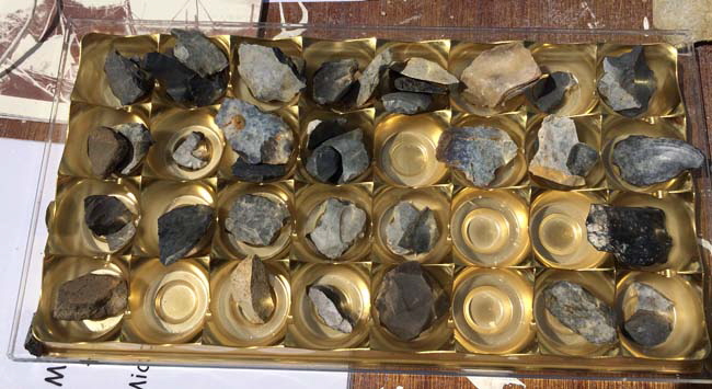
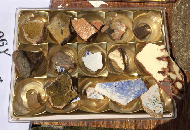
Above and below we see some Mesolithic tools (scrapers and cutters), mediaeval pottery shards and sea shell fragments.
R****TS!
 The fields to the north of the dig site is the place to find lots of little furry animals that run around and burrow. The fields to the north of the dig site is the place to find lots of little furry animals that run around and burrow.
By the way - that’s a sprinting Hare in my animation not a R****T!
Whatever you do, never say or write the 'R Word' on Portland. Stuart Morris, in his excellent "Illustrated History of Portland" never uses the word but refers instead to bunnies, conies, underground mutton, etc.
Other local names include “They Vurry Things” and Wilfreds. This latter comes from the characters Pip Squeak and Wilfred as seen in this 1922 cartoon
Pip, Squeak and Wilfred were a dysfunctional family made up of a penguin mother, dog father and a r****t child.
Whoever invented this family had a very poor understanding of genetics and reproduction!
Old Portlanders have a strong superstition about these furry creatures. If a Portland quarry worker or fisherman saw a bunny on the way to work he would turn back and stay at home all day.
I know one visitor who was being taken on a fishing trip in the 1970s and said the 'R Word'. The boat was turned around and the crew went silently home. So, even today, it is no joke.
There are several stories of the origin of this superstition. Some say that bunnies digging in quarries caused fatal rock falls. Also, when blasting the explosion would sometimes run along bunny burrows and rocks would be blown uncontrollably in all directions. A long exchange of stories in the Dorset Echo in 2003 suggested that neither of these origins was true and that the bunny aversion was a 20th century invention.
Who knows?
In December 2002 huge numbers of dead bunnies were found around Portland Bill due to Myxomatosis.
In October 2005 the film "Wallace and Gromit - Curse of the Were-R****t" was released but posters on Portland were defaced. The media descended on Portland and the ‘Bunny Curse’ was widely publicised. One brave London-based reporter dressed in a r****t suit and hopped around the Island - see here.
Strange to say, within days of Aardman Films posting the r****t pictures on Portland, their entire warehouse of props and models burned down.
Say no more! Nudge! Nudge! Wink! Wink!
That's why I'm not going to give 'that they Underground Mutton' their real name on this website!
Return To Top Of Page
ANOTHER OF MY HOBBIES

Age of 75 I started a new hobby - writing and publishing books. These are available as paperbacks from Amazon - please click here for details. Their overall star rating from readers is 
Keywords Southwell Portland Dorset
|